Historic Route of L'Ametlla de Mar
The route follows the best places in the La Cala, it has 8 stops explaining topics such as the founding of the village by the fishermen of Grau de Valencia and its relation to the Castle of Sant Jordi d'Alfama, religious traditions, the legends of the bandits who inhabited those regions in the XVIII century, the shipwrecks off the coast of Ametlla during the 1st World War, etc ...
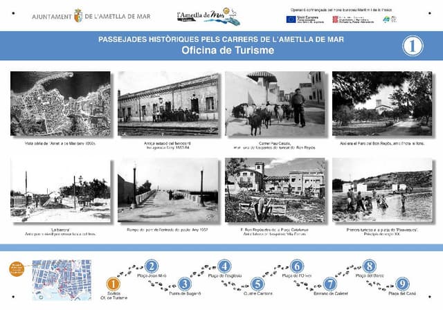
1. Tourist office (Historic Route of l'Ametlla de Mar)
It is the starting point of the tour where we will see a brief summary of all the panels that make up the historic route of Ametlla de Mar. This route can be taken individually or with a tour guide. For more information on the tours please contact the Municipal Tourist Area in Avenida Amistat Hispano Italiana. Telephone: (34) 977456477/977456329. Fax: (34) 977 105 635. Web: www.ametllamar.cat / turisme. email: turisme@ametllamar.cat
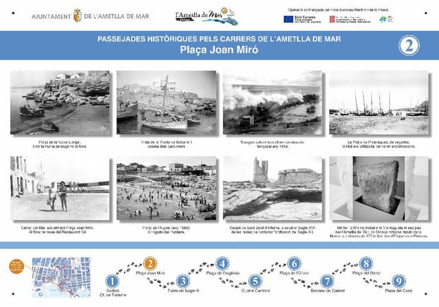
2. "Plaça Joan Miró" (L'Ametlla de Mar's History Route)
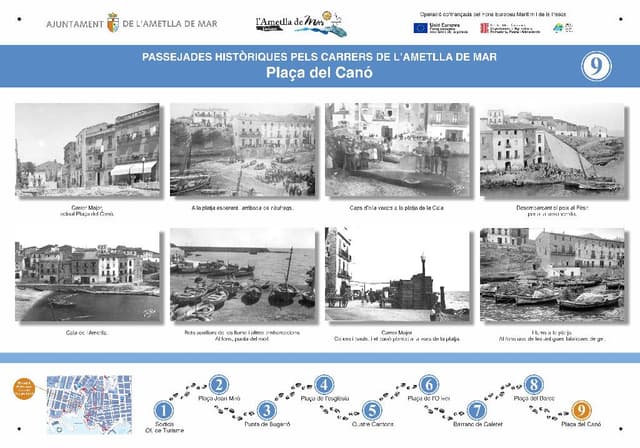
It is the second point of the route. Sant Jordi d'Alfama: In 1201, Peter I the Catholic granted the Templar Order the desert of Alfama, so they could build a fortress and a place of prayer to encourage the repopulation and protection of the area. The order became known as the Order of Sant Jordi d'Alfama. In the early 15th century, it was incorporated into the Order of Montesa, and its name changed to the Order of Sant Jordi d'Alfama and Santa Maria de Montesa. For some time, the fortress was abandoned; eventually, Emperor Charles V appointed a new prior, and the fortress was reinhabited. Foundation of Cala de l'Ametlla: In the second half of the 18th century, the colonization of this area was promoted. When the settlement was created, fishermen as well as peasants from Valls and later from other villages in the region arrived. These settlers stayed close to the castle of Sant Jordi d'Alfama. However, it was the fishermen, led by Joan Baptista Gallart Gafarelo, who began to populate the southernmost part of the area, La Cala de l'Ametlla (Plaça del Canó). The town had to endure the consequences of the wars in the 19th century, but the passage of the railway through the village helped it grow. Finally, in 1891, it became independent from Perelló, as it had previously been a maritime district of that town. It was in 1917 that it received the name Ametlla de Mar. Although the town as a population emerged in the second half of the 18th century, historical traces can be found from antiquity, through the Roman period, as well as various sunken ships, including Greek, Roman, and from both World Wars, such as the Cavour ("Correu"), Chumleigh ("Vapor de Momell"), Medjerda ("Correu d'Oran", from World War I), and Kirissi (from World War II).
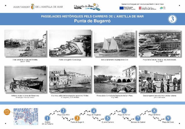
3. "Punta de Bugarró" (Historic Route of l'Ametlla de Mar)
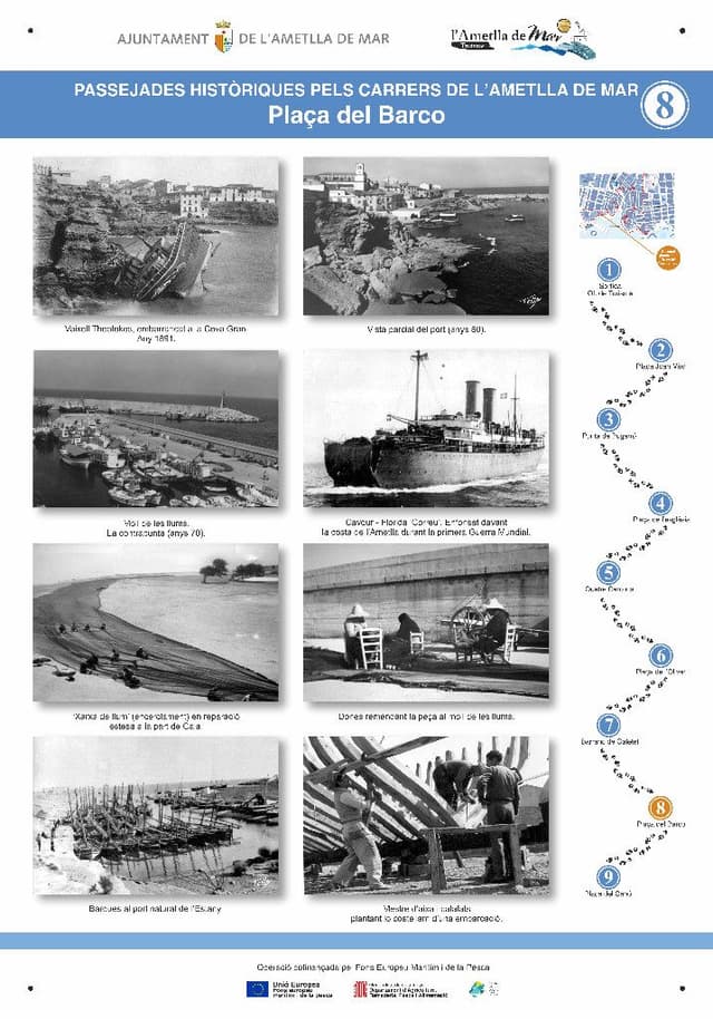
It is the 3rd point of the route. One of the oldest professions of Ametlla de Mar was the chisel masters (now almost extinct), to build and maintain the local fishing fleet. Formerly boats were beached on the cove (Plaza del Cano) with greased poles to slide over. Cova Gran: On this site the Greek ship Theotokos ran aground on Christmas afternoon in 1891 (the year of segregation from Perello). The intresting thing about this shipwreck is that the inhabitants of the la cala dismounted the boat for timber to make beams for the houses and when the ship's owners came looking for the remains they found almost nothing.
4. "Plaça de l'Esglèsia" (L'Ametlla de Mar's Historic Route)
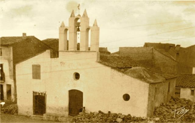
The first chapel is dated from 1816 but is at the end of XIX Century when an extension was requested, but it wasn’t finally finished until 1960. The most important religious festivals are: The Candelera Festival, which is quintessential of the patron saint of the village when "pastissets and corassons" cakes and biscuits are made, aswell as the floral offering and the procession in honor of the town's patron saint, the Virgin of the Candelera. The feast of St. Peter is the second patron saint of the town and was fully introduced from postwar to cheer up the people. Plaza Nova: The square was renovated a few years ago. The square was a fountain and for a long time a fruit and vegetables market.
5. "Amadeu de Savoia" street (Historic Route of l'Ametlla de Mar)
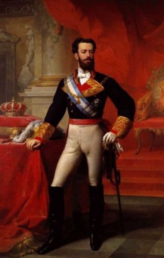
It is the 5th point of this route. The current name of this street is the former Town’s Mayor Llambrich Andreu has a rather peculiar history. The people of the Cala know this street as Calle Amadeu because in 1871 the king Amadeu of Savoy passed through the town and the people went to meet him at the train station, which is on the street itself, and offered various presents.

6. "Llibertat" street (Historic Route of l'Ametlla de Mar)
It is the 6th point of this route. During the war this street was called General Mola street but now is Llibertat Street. On this street there was a biochemical laboratory that sent vaccines across Europe, the physician and bacteriologist Jaume Ferran Clua (bacteriologist who applied rabies shots) created this laboratory for his daughter who lived in Ametlla de Mar as she married a Calero, and as such the street was named in his honor, Doctor Ferran street. Within the history of Ametlla are various legends associated with the assaults on Coll de Balaguer and vaious names for the local people which begin from of the founding of the town.

7. "Barranc del Galetet" (l'Ametlla de Mar's Historic Route)
A legend that is told here in the village is that of the “Old Pistol”. Its said that a fisherman that, during the first Carline war, fished in the morning and in the afternoon went off to the mountains, put on the typical Carline beret, so that he believed that in the area he was protected, and as the soldiers passed they were assaulted. It is said that he lead this double life for some time until he was finally exiled to a church in Mallorca, and from that moment on was never heard of again. The street we have just come down is Dr. Ferran Street, in honor of the doctor, because for many years he had his biochemical laboratory in what is now the hotel "Bon Repos". If you go past the front you can see (looking at the picture) the structure of the laboratory is the same as the hotel. Dr. Ferran discovered the colic vaccine, and perfected the vaccine for rabies. In the back of his laboratory he had horses with the serum of which elaborated the vaccines. Once the vaccines were finished there were distributed to different countries. Another doctor who did great work here in the village was Dr. Frias. At the beginning of the XX century, the infant mortality rate was very high. The doctor worked in l’Ametlla de Mar from 1904 to 1909, and helped families improve their hygiene and food conditions, so that the village could grow. This photo is of the street Candela, which was the first street we had here, and as such has the same name as the patron saint, it was the road used to travel from Perello.
8. "Plaça del Barco" (Historical Route of Ametlla de Mar)
The Plaça del Barco is located at a point in the town known as "La Cova Gran." In this spot, at the beginning of the 20th century, a ship ran aground while seeking refuge from a strong easterly storm. The people of the town came together to help the shipwrecked and, at the same time, took advantage of the ship's materials to build homes. Following this event, a popular saying emerged: “The ship was from Greece, the current from the East, and it ended up in La Cova Grande.”
9. "Plaça del Canó" (L'Ametlla de Mar's History Route)
The Founding of L’Ametlla: Regarding the original centre of the town, the documentation is uncertain until you reach the last quarter of XVIII century. This is due to the momentum of the Charles III settlement when it emerged as the fishing centre of the village Perelló (which it broke away from on Christmas Eve, 1891), coinciding with the progressive arrival and establishment of groups of Valencian fishermen. Its evolution: During the nineteenth century, especially going into the second half, the town consolidated and grew significantly in population, with the influx of people from neighbouring villages (l’Ametlla began the twentieth century with some 2,500 inhabitants, half of the estimated current population). It also received a boost in fishing and agriculture and the commercial subsidiaries, powered by the separation process and the construction of the railway (1860-1870). The early years of the twentieth century were relative prosperous until the thirties recession made the people suffer and generated important migration weakening, which was worse that the migration to Palamos which took place in the years following the civil war, and lasted until the early sixties, when the emerging trend of immigrants and tourists transformed the demographic, cultural and productive face of the town.
...
